A Global Rebound for Mangroves
First reported Fri, 13 Nov 2026 05:01:00 GMT · Last updated
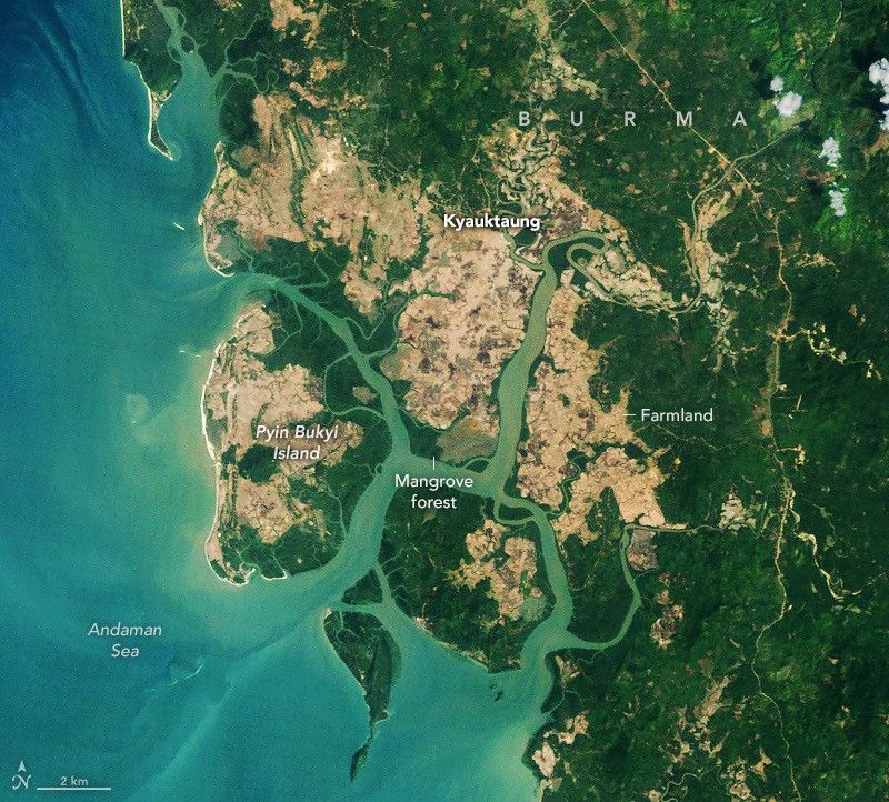
Earth Observatory Science Earth Observatory A Global Rebound for Mangroves Earth Earth Observatory Image of the Day EO Explorer Topics All Topics Atmosphere Land Heat & Radiation Life on Earth Human Dimensions Natural Events Oceans Remote Sensing Technology Snow & Ice Water More Content Collections Global Maps World of Change Articles Earth Matters Blog Blue Marble: Next Generation EO Kids Mission: Biomes About About Us Subscribe 🛜 RSS Contact Us Search 2010 2026 NASA Earth Observatory/Michala Garrison NASA Earth Observatory/Michala Garrison 2010 2026 NASA Earth Observatory/Michala Garrison NASA Earth Observatory/Michala Garrison 2010 2026 Curtain Toggle 2-Up Image Details Mangroves have replaced rice fields in parts of Burma’s Myeik District. The TM (Thematic Mapper) on Landsat 5 captured the image on the left on February 14, 2010, and the OLI on Landsat 9 captured the image on the right on February 2, 2026. NASA Earth Observatory images by Michala Garrison. Scientists began using satellites to map mangrove forests in the 1970s after the launch of the first Landsat satellite. For decades, the story they told about mangroves was dominated by loss and decline. Research published in
1 source in this cluster
- NASAA Global Rebound for Mangroves
Earth Observatory Science Earth Observatory A Global Rebound for Mangroves Earth Earth Observatory Image of the Day EO Explorer Topics All Topics Atmosphere Land Heat & Radiation Life on Earth Human Dimensions Natural Events Oceans Remote Sensing Technology Snow & Ice Water More Content Collections Global Maps World of Change Articles Earth Matters Blog Blue Marble: Next Generation EO Kids Mission: Biomes About About Us Subscribe 🛜 RSS Contact Us Search 2010 2026 NASA Earth Observatory/Michala Garrison NASA Earth Observatory/Michala Garrison 2010 2026 NASA Earth Observatory/Michala Garrison NASA Earth Observatory/Michala Garrison 2010 2026 Curtain Toggle 2-Up Image Details Mangroves have replaced rice fields in parts of Burma’s Myeik District. The TM (Thematic Mapper) on Landsat 5 captured the image on the left on February 14, 2010, and the OLI on Landsat 9 captured the image on the right on February 2, 2026. NASA Earth Observatory images by Michala Garrison. Scientists began using satellites to map mangrove forests in the 1970s after the launch of the first Landsat satellite. For decades, the story they told about mangroves was dominated by loss and decline. Research published in
Fri, 13 Nov 2026 05:01:00 GMT
Timeline
- 2026-11-13 05:01NASA — A Global Rebound for Mangroves
How to read this page
- Headlines, quotes and facts come from the linked original articles (reporting).
- "Newsei analysis" and "Why it matters" are AI-assisted synthesis (inference).
- "Confirmed" means two or more independent outlets reported the same claim.
Methodology · Source profiles & bias labels · Corrections policy · Report an error: info@newsei.com
Share this timeline
Embed shows this story's live timeline on your own site and links back here.